 |
| Heading up Goliath |
Originally Cole, Paul and I wanted to attempt a climb of
Quandary Peak today. With the snow
conditions it didn’t seem like a good idea, so at the last minute we made plans
to climb Goliath Peak. Goliath is a
mountain easily accessed in the summer months along Mount Evans Road. Since the road is shut down for the winter, I
thought it would make for a nice winter snowshoe.
To access the TH drive I70W to Idaho Springs, find a way to
HWY103. The bridge is out so the detour
makes you continue up I70 for a number of miles before turning around heading
back down I70E to exit 240. Once on Hwy 103
follow it for 13miles to the parking area just above Echo Lake. There is a large road closure sign and that
is where this trip began. The forecast
was calling for mostly sunny temps around 5°F with winds of 25mph+ creating
wind chills of -26°F.
As we started gearing up at the TH I didn’t think the temp
was all that bad. The reason for this
was there was no wind at all. This was a
nice teaser that would soon change for us.
The trail appeared to have about 4-5inches of fresh snow, and there were
tracks from the previous day. I started
just wearing micro spikes then about 100yds up the trail put on my
snowshoes. I figured why carry them when
I could just wear them. The temps were
cold as expected, soon I was growing icicles on my face, and my nose had frozen
all together.
 |
| Beautiful Day |
By the time we hit the first mile marker the sun was
starting to peak through the trees. We
rounded the corner and had the long mile and half switchback ahead of us. We decided to stay on the road as the trees
were very thick and seemed to have a considerable amount of deadfall. That would have made for a frustrating hike,
but the road was very pleasant. There
was hardly any noticeable grade, so it felt like we were just out for a walk in
the snow. Cole and Paul were blazing
ahead and I soon gave up even trying to keep up with them. I was trying not to sweat, because that perspiration
would just freeze making me colder.
At the end of the long switchback we were nearing tree-line
and the sun was out in full force. We
sat there for a moment, shedding a few wet/frozen layers from sweat and taking
a small fuel break. At this point we had
our first view of Goliath, and we could see the wind whipping off the summit
ridge. The sky was clear so we snapped a
few pictures then headed down the road.
Nobody had been up this far lately, or the snow had just filled in the
tracks so we had a small sense of solitude which was nice.
 |
| Summit Shot |
We passed some sort of visitor center and stayed on the road
as it made its way around a few short turns.
The wind was getting crazy so we all put our shells and goggles on
before making the final turn. Once we
saw where the wind swept ridge connected near the road we headed cross country
to meet up with it. We planned to stash
our snowshoes along the base of the ridge and boot it up the final 300 feet to
the summit.
The wind was un-relenting; I would guess sustained 40mph+
and gusts of 60mph that created white-out conditions. After caching our snowshoes we made quick
work to get on the summit. The winds
calmed enough for us to take some pictures then we headed down to our gear
cache. It was a tricky, slippery descent
to the gear but nothing as bad as James Peak about a week ago. We made our way to the visitor center
building to try and find some shelter from the wind to have a beer and some
food.
 |
| Mount Evans Group |
We had our slush-beers and found no real shelter. We knew it was time to bug out, so we got on
the move as fast as we could. I had my
hands exposed for about a minute and I damn near froze my fingers off. I spent the next thirty minutes or so trying
to get the blood flowing again. Nothing
hurts as bad as getting the blood flowing again…makes you want to scream. We were all in the same boat, so I’m guessing
the weather forecast was pretty accurate today.
The best idea was to keep moving so that’s what we did. Never stopping for more than a few seconds,
we were on a march out to the parking lot.
On the way out we passed a few people along the road. The trail was in pretty good by now, so I
could see that this is a heavily used area.
It was about 2pm when we made it back to the car. The lot had about 6 or 7 other vehicles and
the Echo Lake lot was full of 20+ vehicles.
For being so popular we had a nice day of solitude above tree line. It was a cold wintery hike but we all learned
a lot about keeping warm when the weather gets frigid. It’s fun to hike in the winter, but proceed
with caution and be prepared.
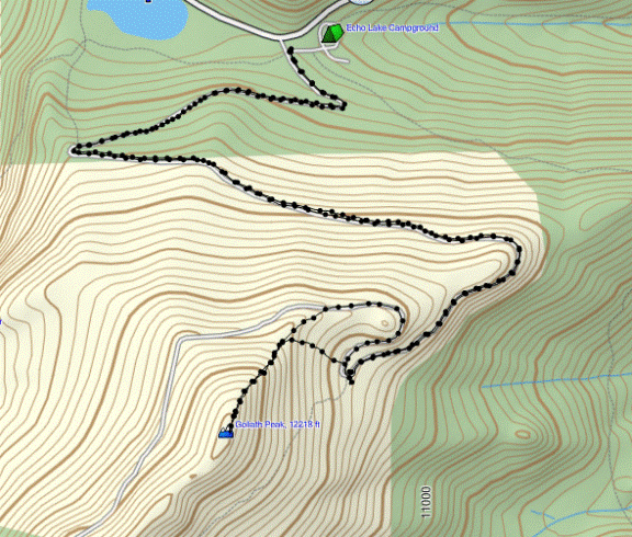 |
| GPS Track |
Date: 12/27/2014
Starting Elevation: 10,680ft
Goliath Peak: 12,218ft
Total Gained Elevation: 1,540ft
Distance: 7.42 miles
Moving Time: 4:20
Stopped Time: 1:30
Partners: Cole and Paul
Picture Link: Goliath Peak Photo Album
No comments:
Post a Comment