 |
| Me on the Summit |
 |
| Coyote |
For today I was looking for a quick hike since Kristi was
working a half day. About 10pm last
night I decided I needed to get out and found Green Mountain via Summit Post
and made plans for a Friday morning hike.
Green Mountain is only about a 30 minute drive from my
place, so I was in no hurry to leave this morning. I hung about the apartment waiting for the
temp to rise a bit and finally left around 9am.
I chose to take C470 to Alameda Parkway, follow the parkway to the east
turning left at a stoplight. Turn northeast continuing what is still Alameda and
park at the TH location off of Utah or Florida Ave. I parked at the small lot off of Utah Ave, if
I did it again I would head up to the Florida Ave lot which is much bigger and
the loop trail works a lot better from there.
The online maps I found were sketchy at best so I was kind
of on an exploratory hike today. As I
left the parking lot the trail was snow/ice covered and a bit slick. Not worthy of traction, I just had to be
mindful of my steps. For my ascent route
I took the John O. Haden Trail, which is easy to navigate with signs at each
intersection. The trail was mostly a
single track, but it did widen in some areas.
There had been some bikers on the trail since the snowfall yesterday and
a few footprints, but not much that I could see in the way of humans at the
time.
 |
| Mount Morrison |
Eventually the John O. Haden Trail connects to the Green
Mountain Trail, which is more of a road.
This is on top of the flat summit ridge north of the radio tower. From here it is a short rolling road walk to
the true summit of Green Mountain. The
summit area is flat with a tiny rock cairn.
I found a large boulder which I think had a benchmark attached to it at
one point, but is no longer there.
 |
| Longs Peak |
With the temps around 30° and hardly any wind on the summit it
was very pleasant. I took the typical
pictures then walked over to another high point on the ridge to check it
out. There wasn’t much on the other
point than a larger cairn. I started
back along the trail, which is much more of a road on top.
For the descent I stayed on the Green Mountain Trail to see
where it went. I recommend if you take
this route and parked at the lot off of Utah Ave to turn west when arriving at
the John O. Haden Trail intersection. I
stayed on the main trail and it took me to the lot off of Florida Ave. From there I connected on the trail that
leads around the mountain till meeting back up with the Utah lot.
This was a great easy hike.
It reminded me of hiking Table Rock back in Boise, but with less
elevation gain. I made a loop, but this
could be done from many ways. I would
love to do this as a full on snowshoe with about 8 inches of fresh powder
sometime. We are off to Idaho on
Tuesday, so hopefully another trip report will come out of that.
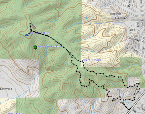 |
| GPS Track |
Starting Elevation: 6,094ft
Green Mountain Summit: 6,847ft
Total Gained Elevation: 753ft
Class: 1
Distance: 4.93 miles
Time: 1:58 moving, 15 stopped.
Climbing Partner: Solo
No comments:
Post a Comment