Sunday, June 22, 2014

Mount Wilcox

Mount Wilcox
Mount Wilcox has been on my list for some time now.  I have gridded the area from I-70 to the north covering all the major peaks along the corridor to Geneva Mountain to the south.  This was the last peak I needed to finish the Guanella Pass area.  I have been to the Wilcox area about four other times, but multiple peaks sometimes don’t work.  Here I am back to climb Wilcox, and from a different route.  I find it’s always good to have company and it didn’t take much convincing to get Cole and Jenny to head out with me.
We met at 5am in Denver and made the drive up to the Silver Dollar Lake TH.  To get to the TH head to Georgetown and follow the Guanella Pass road till you pass the Guanella Pass CG.  Just after the CG there will be a road heading off to the right called Naylor Lake Road.  This road is a dirt road and can be a little rough.  We had no problem with Jenny at the wheel of the Subaru.  About a mile up the road is the parking for the Silver Dollar Lake TH.  We arrived about 6:30am and were off on the trail a bit before 7.
Silver Dollar Lake and Squaretop Mountain
The area surrounding Naylor Lake is all private property so this trail is the best access to the mountain.  Beware that we heard gun shots on our descent, so this area is probably a gun club or militant camp..haha.  One thing to note was my GPS was not working well at the beginning of the hike.  It kept beeping saying it was losing satellite service.  That is why I don’t have complete data for this trip, but I’m sure you can piece together all the missing parts.
I made the bad decision of eating some McDonalds before the hike and I wasn’t feeling to well from the start.  We slowly made our way up the trail until I got my body working.  There was quite a bit of snow along the trail, as it opened up above the lake the snow fields were quite large.  Depending on your comfort you could bring micro spikes or walk across it with good boots.  I was fine in boots, but then again I love snow.
As we worked on the traverse towards Silver Dollar Lake we saw a Mountain Goat high up on Squaretop Mountain.  The picture I took was zoomed in as far as I could get, so he was up there quite a ways.  Cole was naming of the birds as they buzzed by us, it’s always good to have people around with different knowledge banks.  The trail got muddy and wet as we approached Silver Dollar Lake.  Jenny got a good soaking so we took a minute at the lake for personal maintenance. 
The terrain rises a bit towards Murray Reservoir and the trail disappears beneath the large snow fields.  We just headed directly up and had no problems not using any traction.  As we approached Murray we started discussing our options for the day.  This route is really easy for a combination of a couple peaks.  Argentine is just to the west of Wilcox along the same ridge.  Cole and Jenny wanted to go for it, so we started making a more direct route through the rocks towards Argentine.
Grays and Torreys
I recommend our ascent route, primarily because there are some really cool rocks.  With that being said, we didn’t make much progress.  We all love rocks too much and found ourselves rock hounding more than hiking.  At one point we found this large pegmatite boulder and out came the rock hammers.  You have to love geologists.  It is always nice to be on a laid back trip with lots of time for discussion.  All three of us took Geomorphology during the spring semester together so we all love calling out all the different landscapes we see as we go.  Geologic discussions in the field are one of the things I enjoy most, especially in the mountains.
My legs were pretty beat, probably from a lack of use.  These desk jobs are not all they are cracked up to be.  I decided to tell Jenny and Cole to take off for Argentine without me and I would meet them on the main ridge.  They agreed so we split up a few hundred vertical feet of the main ridge.
I found an awesome rock rib to climb up.  There was some beautiful metamorphic rock with very cool pegmatites.  I love to be adventurous so I put together a nice class 3 route, but there are easy ways to navigate around the rocks to stay on class 2 terrain.  I climbed up maybe 50 vertical feet of killer rock then the grass terrain came back in leading towards the ridge.  It didn’t look like Cole and Jenny were running up the mountain so I started rock hounding again.  I found some nice rose quartz among other rocks that would continue to weigh my pack down.

Pano from Squaretop to Torreys
Cole and Jenny had just made it over the first false summit and it looked like they had decided against climbing Argentine, as the weather was starting to turn.  Just then I spotted two ptarmigans in the rocks.  I always love finding these birds, and they seem to like being photographed.  I waited there so Cole and Jenny could check them out.
Now that we were re-grouped we started heading towards Wilcox.  We probably only had about half mile and 700 vertical feet to go, but at 13,000ft that can go pretty slow.  I was breathing pretty hard, so I took my sweet ass time.  The rocks along the west ridge are neat and I kept finding my pockets full of new specimens.  After a good march up the mountain we finally summited.
The weather was getting dark and gray, but nothing bad.  We enjoyed our solo summit, unlike the 100 people on Bierstadt across the road.  Cole brought up our summit beers and they were ice cold.  The funny thing was, we needed to put our gloves on to hold the chilled beer.  It started to snow graupel on us just as we decided to hit the road; I guess someone was telling us it’s time to get going.
Summit Beers
We decided to make a loop out of this trip so we just had to head down the gentle slope of the mountain, find our way through the trees and hook up with the road.  I had been on most of this part before, so it was nice knowing I kind of knew where to go.  We found our first snow field and I wasn’t about to walk down it, a glissade opportunity was finally here.  It was probably only 100 vertical feet down, but I’ll take what I can get.  Cole and I enjoyed watching Jenny do her first glissade, it was quite acrobatic.
The next snow field was rather steep and had no good run out so I told them we should just walk it.  The snow was a bit harder and it took us a while to cross it, but we were never in a hurry.  Always play it safe.
Once off the snow we had the willows to deal with.  Cole took point, and by the time he was done with them you would think a moose had trampled through.  On the other side it was a simple hike through the woods.  The down fall is pretty bad in this area, but we didn’t have any issue navigating our way through.  We started hearing gun shots so that was a little sketch.  As we kept making our way down it seemed like they were coming from the other side of the lake, so we slowly made our way to the road.  We met up with the road about 100 yards into the private property.  It wasn’t well staked so, keep that in mind if you use my GPS map for future hikes.
I highly recommend this route for anyone wanting to do Squaretop, Argentine or Wilcox.  We all enjoyed it, and the bonus is there are no people like the over populated 14ers.  I love the solitude of the 13ers; they are way more fun too.  Our next stop was Beau Jo’s in Idaho Springs for some mountain pie and beer.  And it was amazing.  Till next time. Cheers!
GPS Track
Date: 6/21/2014
TH Elevation: 11,200 feet
Mount Wilcox: 13,408 feet
Total Gained Elevation: ~2,260ft
Class: 2
Distance:  ~6 miles
Time: Lost Data 
Climbing Partner: Jenny, Cole

Tuesday, June 17, 2014

Rocky Mountain National Park: Estes Cone, Emerald Mountain

Estes Cone
Kristi and I have been talking about getting out and doing some camping this summer and our opportunity finally arrived.  I was able to get the last spot at Glacier Basin Camp in Rocky Mountain National Park.  We just bought a new tent last week since our old tent ripped on our last adventure to the park about a year and a half ago.  Cole and Jenny were able to join us, so we had a small crew heading up for two days hiking and one night of camping.
The tough decision for RMNP is deciding where to hike.  There are so many great places, and the hard part is getting away from the hordes of people.  I really wanted to do a summit hike so I could get a nice view of Longs Peak in.  A few years ago I did the Twin Sisters Peak hike which I highly recommend, so I wanted a new peak.  The answer was easy and it was literally across the road; Estes Cone.
Estes Cone
The hike of Estes Cone starts from the Longs Peak TH.  This is located along HWY 7 to the south of Estes Park.  The parking lot will remain full for the remainder of the summer since this is also the TH for Longs Peak, so expect a lot of people.  The good news is that most of the people will be making their way towards Longs or Chasm Lake, leaving the trail to Estes Cone relatively free of traffic.
Cap Rock
RMNP Pano
From the TH, the hike is about 3.2 miles to the summit.  The first half mile runs along the Longs Peak Trail, then there will be a split that is well marked heading to the north; this is the Estes Cone Trail.  After this split it’s roughly another mile to the Eugenia Mine which is located along the Inn Brook Creek.  There is little left of what was apparently “produced more dreams that gold” as the sign states.  It is a nice area for a breather, but the mosquitos were pretty heavy so we pushed on.
The trail kind of tricks you here, instead of going uphill the trail heads down.  There is a nice meadow after the short descent that gives a open shot of the mountain.  Once meeting up with another trail junction the gain is steady to the top.  Another junction .7miles up the grade is where Estes Cone Trail and Storm Pass Trail meet.  From here it the main trail fades in the first few hundred yards and a climbers trail leads to the summit.
Nick and Cole Checking in on Longs
Follow the cairns and it’s pretty easy to stay on a decent trail to the top.  It is only .7miles from the last junction so it can go pretty quick, or not.  We took our time because this was our only hike for the day.  There is a nice short scramble through the cap rock to the summit.  Once on top the views of Meeker and Longs are amazing, even better than from the summit of Twin Sisters.  I took the opportunity to do a father’s day photo.  We hit the road to get back to camp and relax for the rest of the afternoon.
I must say one of the funniest parts of the day was driving by the line of cars waiting to pay at the park’s entrance.  Sometimes those annual passes are really nice; you get to open the gate with a swipe of the card.  At camp we were discussing options for the next day.  We came up with the idea of hiking Emerald Mountain from camp.  This was barely 500ft, but it still counts in my book.  Then after our morning hike we would head to the Bear Lake area and do a hike to one of the many lakes with all the other tourists.
Emerald Mountain
Jenny, Cole and Nick on Emerald Mountain
This is a small peak, but it we made a fun route through the woods and up the rocks.  There may have even been some prospecting along the way, but I can’t confirm that.  We took about as direct of a route as possible, once through the trees there was a good game trail leading up through the large rock outcrops.  This just took us over half hour to ascend, a good way to start the day.  This was a great place to view a lot of the glacial geomorphology of the park.  The moraine park to the north was quite impressive as were all the cirques to the west.  This made it well worth the effort.
Nymph and Dream Lakes
Longs Peak
We were looking for an easy hike to lakes or waterfalls, unfortunately so was everyone else.  This part of the park was packed full of tourists getting in an easy hike.  The beauty of this area is the backdrops of the mountains.  Hallett Peak looks like it made my list, and has an amazing view from Dream Lake.  This would be a great place for a snowshoe in the winter and maybe the traffic would be down around then.  As we descended the trail the arête to the east was quite impressive.  I was glad we were able to sneak another hike in for the day.
We all had a beer and some lunch from Oskar Blues on our mind, so we made our exit pretty quickly.  I can’t say I recommend hitting up Oskar Blues on a Sunday, the wait was pretty ridiculous.  But, when you’re with good friends it doesn’t really matter.  It was a great weekend, now it’s time to climb some real mountains.
Estes Cone GPS Track


Date: 6/14,15/2014
Estes Cone TH Elevation: 9,375ft
Estes Cone Summit : 11,010ft
Total Gained Elevation: ~2,000ft
Class: 1-2
Distance:  6.4 miles
Time: 4:00 moving, 2:00 stopped. 
Climbing Partner: Kristi, Jenny, Cole


Sunday, June 1, 2014

Devil's Head Fire Lookout

Devil's Head Fire Lookout and Pikes Peak
It’s been two months since my last post, that feels like a eon.  Spring and Maymester at school were quite busy so this was my first opportunity to get out into the mountains.  A month or so ago Kristi asked me about the Devil’s Head Fire Lookout.  I had no idea what it was, but apparently it is visible from her office area.  This is a short hike reasonably close to Denver; we thought it would be a good fit for a Sunday morning hike.  Jenny and Joel wanted to get out on a hike and we were happy to have some new friends along for the day.
Pikes Peak
Getting to Devils Head FL is pretty easy, and any operational vehicle should be able to reach the TH without any difficulties.  Find your way to HWY 85 heading south towards Sedalia.  From the “village” of Sedalia head west on to CO 67 for about 10 miles till the road intersects with Rampart Range Road.  Turn left (south) where the pavement ends and a decent dirt road will lead you to the TH about 9.25 miles down the road.  There are signs the whole way so chances of getting lost are minimal.  I will warn you this is a heavily used road and covered in washboard.  Be careful of the teenage drivers in dad’s truck taking up the narrow roads.
From the TH this is a pretty straightforward hike.  It is about 1.5miles to the fire lookout and the elevation gain is not too bad.  The area is well covered with trees and there are large monolith boulders of weathered granite.  Just expect to see everyone you have never met from Denver; the trail was quite busy for us today.
The Crew: Nick, Kristi, Jenny and Joel
The fire lookout sits on top of a large monolith of granite, so to make it accessible there is a grand staircase in place.  From the base of the steps there is a climb of 143 stairs to the lookout.  Everyone is huffing and puffing at this point so don’t be ashamed.  After the climb is over the lookout seems rather small.  This is a manned lookout, so there will be a ranger present during operational hours.  The views are amazing; I would say this is the best view around of Pikes, so maybe you will get lucky with good weather. 
STAIRS!
We hung out at the lookout for about 15 minutes.  Thanks to Jenny for bringing up rice crispy treats for us, one of the best mountain snacks I’ve had in some time.  Next time I would bring up some binoculars for the far off view of the mountains.  As the hordes of people kept coming up the stairs we knew it was time for our exit.  It took a little patience with the other humans, but we eventually made our way down to the earth and rock.  The staircase is pretty impressive and can give you a small rush if you look down in the right spots.
As we descended the trail the amount of people heading up kept increasing.  The parking lot was over stuffed, so If you head up come early or carpool with others.  I think we all really enjoyed ourselves on this short hike today.  Hopefully there will be more of these to come, since everyone in the group wants to get up their first 14er this summer.
One last thing.  My biggest supporter of my blog, my Aunt Janet is not doing well.  I know that you will read this or listen to it.  I think about you every time I'm in the mountains and look forward to climbing my next one since I know you will be there to help me overcome the mental obstacles that always try to bring me down.  I love you and just want to know how much I appreciate your support.
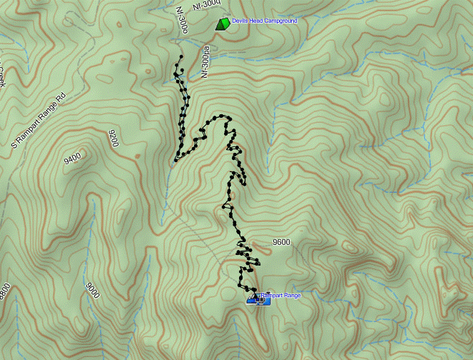
GPS Track

Date: 6/1/2014
TH Elevation: 8,826ft
Devil’s Head Fire Lookout: 9,748ft
Total Gained Elevation: ~900ft
Class: 1
Distance:  3.08 miles
Time: 1:36 moving, 0:40 stopped. 
Climbing Partners: Kristi, Jenny, Joel

Tuesday, March 4, 2014

South Boulder Peak and Bear Peak

The Boulders
It seems like it has been a really long time since my last trip report.  Well I guess it has, this is my first post of 2014 and it is already March.  School is a real bummer, always getting in the way of my mountains.  But, lucky for me my Mineralogy class was cancelled and a test was moved back a week so I figured I could sneak a mountain in.
I had a hunch that Brian might be in for a climb so I put the bait out there on Facebook and he bit the line. We didn’t have much time to plan and look into weather and conditions, so we decided to stick to the oxygen laden peaks of the Boulder Flatirons.  In the fall we had tried this route, but halfway up the mountain the trail was closed and we were forced to abort.  I checked online and the trail was open so we were a go for South Boulder Peak and Bear Peak.
South Boulder Peak
Brian found a route that has a nice loop of the two peaks so that was our plan.  About 9am we were off on the approach from South Mesa TH.  Beware this is a fee area so bring $5.  There was a nice snow/ice covering from the parking lot and soon after crossing the creek we could see a few trail closures. 
\
We stuck to the west ridge trail called the Homestead Trail for our ascent. This is a gradual rising trail that after about 1.5miles meets up with the South Shadow Canyon Trail.  The South Shadow Canyon Trail is more of a road than a trail, but it doesn’t last too long, probably about a mile till connecting to the true Shadow Canyon Trail.  Lucky for us the sun was out melting all the snow off the trees and giving me a nice  morning shower.  It was quite odd, but it wasn’t cold so that was nice.
Bear Peak
I’m not sure on the exact mileage and gain but a rough guestimation of the Shadow Canyon Trail is about 1.5miles and 1,600ft.  So there is a steady grade, but the canyon is pretty cool.  The lower section is all covered in trees, very green and had some sweet geology.  Soon you will find out where Boulder got its name, there are huge boulders all along the trail.  Anyone that is into geology will have a fun experience looking at the different rock types and weathering patterns, so head up there if you haven’t yet.  I may have even discovered a dinosaur bone in a large sedimentary boulder.  I am going to have one of my professors confirm that though.
Once you make it to the fire line that means the saddle is close.  And this is the best area to find the mineral orthoclase if you’re looking for a good specimen for your collection.  I got a few pieces that I’m pretty excited about.
Bear Peak Ridge Looking into Boulder
At the saddle we turned south towards South Boulder Peak and about half mile and 300ft will put you up on the rocky summit.  This was all on a trail, mostly covered in snow and ice so some traction like micro spikes are recommended.  We didn’t take too long on the summit since we were heading over to Bear Peak next.
It is probably a mile in-between the two peaks with a loss of 300ft and a gain of 200ft or so along a trail.  There is a short rocky ridge, basically the top edge of a flatiron you get to scramble over for about a hundred feet which will be the excitement of the day.  Boulder looms below and there are some great lounging rocks at the summit.
After enjoying my PB&J it was time to head down.  We took the north ridge on Fern Canyon Trail.  This was quite steep and covered in snow and ice.  I don’t think this would be wise without traction, so put on your spikes.  The drop is quite quick and I was glad to be going down rather than up at this point.  After converging with the saddle you start heading down a bunch of tight switchbacks then into a tight canyon similar to Shadow Canyon.  This goes for what seemed forever since I took off my spikes on a long dirt section, then the ice came back and I was too lazy to dig them out again.  So it was careful steps for close to a mile. 
Me and Brian on the Summit
Instead of looping all the way around on the Fern Canyon Trail we took a shortcut using the North Fork Shanahan that meets up with the Mesa Trail.  Once on the Mesa Trail it’s a 3.5mile trudge back to the parking lot.  I say trudge because it was very muddy with the snow melt during the day.  A few times I had to stop and clear the mud pies off my boots.  I felt we made good time even with the conditions as they are.
It turned out to be exactly a 10 mile loop.  This could be shortened by about 2 miles by just descending the Shadow Canyon trail rat

her than doing the loop.  It’s not a bad hike though, I found it enjoyable even in the mud and muck.  The parking lot didn’t have a sign of snow like the morning.  It all melted out and left a nice mud bowl though.
This will be the last climb Brian and I do for a while since he is moving to California.  I’m glad we were able to sneak it in and get a 2fer in the process.  It was a great day, just like every day in the mountains.

GPS Track
Date: 3/3/2014
TH Elevation: 5,633ft
South Boulder Peak Summit: 8,524ft
Bear Peak: 8,458ft
Total Gained Elevation: 3,250ft
Class: 2
Distance:  10 miles
Time: 5:10 moving, 2:15 stopped. 
Climbing Partner: Brian


Picture Link: https://plus.google.com/u/0/photos/115877356129727775322/albums/5987063500617973969

Sunday, December 29, 2013

North Star Mountain - Sub Summit

North Star Mountain
Another round of snow is heading towards the mountains, so that means only one thing: it’s time to try and squeeze in another big climb.  I have wanted to climb North Star Mountain since my first ascent of its neighbor Quandary Peak a few years ago.  North Star makes a great winter objective for anyone, there is minimal avalanche danger and any car can make the drive to Hoosier Pass as long as the roads are open.  I sent out my regular Facebook request for a partner and Paul said he was in.
I had to work Friday night closing the store so I was on minimal sleep when I rose for the day.  I have now decided that I cannot do these long drives for climbs the morning after a closing shift.  The exhaustion took its toll, so I will stick to more local climbs for those days.  I was over to Paul’s place by 6:30am and we were off.
Getting to the TH of Hoosier Pass is pretty simple and there are a few ways of going about it.  We chose to take HWY 285 to avoid all of the ski traffic on I70, but by going either way simply turn off on State HWY 9.  Since we came by the way of HWY 285 we turned north on HWY 9 in Fairplay and followed the road past the “smallest incorporated town in the U.S.”  of Alma before arriving at Hoosier Pass.  Don’t worry you won’t miss the pass, there is a large parking area on the west side of the road and there will probably be a bunch of cars there already.
Mount Lincoln
As we arrived at Hoosier Pass, there was a good 12-15 vehicles already there.  We geared up and by 8:30 we were ready to start our climb.  I must add that it was frigid cold as any winter excursion should expect.  Normally I don’t keep my down vest on for climbing, it’s more of a warm driving vest, but today I decided to roll with it on.  After our first three minutes on the trail, we found the sledding hill of sledding hills for the locals.  I would rate this hill extreme, and I could hardly believe kids were up there at 8:30 in the morning hitting the hill hard already.  Maybe it is their warm-up for the ski hills that don’t open till 9am.
The trail was hard packed snow, so no snowshoes or microspikes were warranted.  The first 1.3 miles follows an old mining road to a small saddle of sorts after a bend in the road around a large mound to the south.  I think in the summer you can drive a 4WD vehicle to this point saving a little bit of a road walk.  But with only gaining 500ft and just over a mile, I’m not sure it’s necessary for this peak.
There are a few ways to go about this mountain now that you have arrived at this mini saddle.  There is a road that wraps around and the conditions went from hard pack to unconsolidated to sections of dirt.  It just depended on the drifting.  We chose to get off the main road and start on a direct approach of the southeast ridge.  In the distance, maybe a half hour ahead of us we saw a group of about 7 people and 2 dogs ahead.  I think they chose the road, but the best part about mountains is it’s a “to each their own” type of situation.
Quandary Peak
As we started up the ridge direct the snow conditions were quite variable.  One second the wind packed snow would be like glacier ice, the next second I would be knee deep in some crusted powder.  Yesterday somebody had posted a conditions report on 14ers.com for this route, so we trusted their report.  They said no need for snowshoes or microspikes.  After the fact I would agree, our route snowshoes would have been nice, but only for a short period of time.  Now, if you’re heading up in the future with the new snow, some 6inches or so, looks like you will need some flotation.
The wind was pretty unbearable the entirety of the ridge.  Although it was not snowing, we had plenty of snow blown in our faces, which makes moving upwards difficult.  A time or two we had some layering adjustments, but there really wasn’t a way to make ourselves comfortable with the wind.  We just kept a slow pace that ensured we didn’t need to stop; therefore we would not freeze like giant popsicles.  With a group ahead of us we were at least able to monitor our progress and I think both of us were satisfied.  I think Paul was very happy with his acclimation since he was up in Michigan for the last few weeks.  I’d say he was kicking the mountains butt for being at such low elevations for so long. 
Pano Lincoln in Center
The further we made it up the mountain the more bone chilling cold it got.  We made it to the sub-summit of 13,400ft which Garmin and Google Earth consider the summit.  But, deep down we knew we had a good mile long ridge walk and a few hundred feet to gain to and from the true summit.  We thought about it for about two seconds, but once on top of the sub-summit it felt as if the temp dropped about 30 degrees and the wind picked up about 10mph from what we were previously experiencing.  My fingers went to straight frozen almost instantly and I could not even feel my face anymore it was a frozen ice clad mess.  I spent about 30 seconds taking pictures and told Paul I was heading down.  The feeling of frozen fingers is never a good one, I kept shaking them as much as I could to keep the blood flowing.  Once off the sub-summit we found a bit of a wind block and I pulled out my mittens and grabbed some fuel for the way down.
Sub Summit
Winter climbing as we can see has its immense challenges.  This time it was the freezing wind, had it not been for that we would have kept on route to the proper summit.  Both of us have no desire to make ourselves totally uncomfortable and overextend our limits so we had no problem turning around.  In the summer, this hike would be a breeze, but what fun would it be without a worthy challenge such as a winter ascent?
After I got feeling back to my fingers we loaded up and started making our way down the mountain.  I swear that about a half hour after we started down the wind died.  I kept telling myself that it was still a frigid hurricane at the top to make myself feel a little better about turning back.  Either way I think the both of us had an excellent day on the mountain and were both running on emptied our tanks at that point.
This is an excellent climb for those wanting to get your winter snowflakes on any lists you may have.  There is no technical difficulty, just use good judgment with the weather.  I hope to be back this winter; the views alone are worth the trip. 
GPS Track
Date: 12/28/2013
Starting Elevation: 11,533ft
North Star Mountain Sub Summit: 13,442ft
Total Gained Elevation: 1,925ft
Class: 2
Distance:  5.43 miles
Time: 3:30 moving, 1:15 stopped. 
Climbing Partner: Paul

Thursday, December 19, 2013

Rosalie Peak

Rosalie Covered in Snow
After my failed attempt on Guyot yesterday I had a sour taste in my mouth.  I wanted to get back out but wasn’t sure where I would go.  The motivation seemed to be lacking, otherwise this decision would have been much easier to make.  I started thinking about south facing routes within an hour or so of town.  Now, I wasn’t thinking too hard because I went to bed without any plan in place for the next adventure.  I slept in waking up around 7am.
Still unsure what where to go, I pulled up my topo program on the computer and started searching.  I decided to go back to the Tanglewood Creek area which I have been four or five times this year already.  From the Deer Creek TH there are many options: Mount Logan, Kataka, Bandit, Rosalie, Royal or the Pegmatite Points.  Then there is always the option of just having a nice snowshoe without a summit, so there was a plethora of opportunity, but Rosalie is always the target.
To get to the Deer Creek TH head south on HWY285 from the metro area, turning north on County Road 43A which turns into Deer Creek Road (43).  Follow the main road (43) for about 7 miles till there is a jog to the left, hang a left following this road towards the Deer Creek CG.  Follow the dirt road along the north side of the CG for about a mile ending at the Deer Creek TH.
Tanglewood Tree
Since I was not in a hurry because I really thought this would be a snowshoe trip with a view I didn’t arrive at the TH till about 10am.  This is probably the latest start time I have ever had, but it was nice to have a relaxing morning.  I geared up attaching my snowshoes to my pack and I was off. 
The trail was covered in snow from the beginning, but it was a hard pack so I decided to see how long I could go without shoeing up.  Good news is the first bridge has been repaired; it was washed out during all the Colorado flooding earlier this fall.
At 1.10miles there is a junction with the Rosalie Trail, but for this climb stay on the Tanglewood Creek Trail.  Right around mile 2 the pack on the trail was not so great so I decided to put on my snowshoes there.
There are some deviations to the trail this winter compared to other times I have been up this way.  The long switchbacks are few and the gain is more direct to the clearing of tree line above the willows.  Those that have been on the trail before I’m sure will notice it, and this made the trail much fainter which would become an issue later.
After about 2.5hours of hiking I was finally coming out of the forest.  The last section was very taxing to me, so I was already contemplating my plan for the day.  I was moving at what felt to be a snails pace, but I was still moving up the mountain.  I was shocked to see this make-shift trail came out just below where the normal trail exits the forest.  That was good to know I was at least in the right area.  Now that I was back on the normal route I did the traverse that brings you about 600ft below the saddle of 12,000ft.
View to the Southwest as the Sun Fades
I started up the snow drift infested tundra and found no consistency in the snow pack.  Some areas were ice hard and some were pillow soft.  After gaining another 200ft I found a spot to sit and have lunch.
I was dog tired and had basically given up on a shot of climbing Rosalie at this point.  For lunch I packed a Skippy PB&J, so I gobbled that down with some Gatorade.  After a good 20 minutes I decided I should probably pack up and head down.  As I was attaching my snowshoes back on my pack I kept looking up at the saddle.  As far as I was concerned I was still heading down the mountain, but something was pulling me up the hill at this point.  So, I just followed my feet.  Call me crazy but it was like I was being given an invite to continue upwards.  I told myself I would hike to the saddle then I would at least have a high point of 12,000ft before heading home.
We have all been in this situation at one point.  You sit there and ponder the mountain and think how long could it possibly take, and then you just start hiking.  From the saddle I had about 1,600ft go, but thankfully most of the route was free of snow.  My traverse lead me a little above the saddle so I had a slight advantage and convinced myself that I was going to climb Rosalie today.
The main issue now was light.  With the winter solstice right around the corner, the daylight vanishes very quickly.  I left my lunch break around 2pm, so there was only about two hours of light left before the dark set in.  Lucky for me I always pack a headlamp. 
The Saddle and the Pegmatite Points
Once on the ridge there was a sense of newfound energy.  I think there is something to be said about Skippy PB&J, the energy I had was immense.  I felt like I was moving well, till about 12,800ft.  The sledge hammer hit me and I started taking bits of the mountain at a time.  The snail pace was back, and right in front of me I could see the sun lowering at a quick rate.  It was literally one foot in front of the other over the last 700 vertical feet.  I was pretty spent, but kept moving at a somewhat steady pace, that is when I wasn’t gasping for oxygen. 
At 3:30pm I finally made the summit of Rosalie.  It was a great feeling and the wind was blistering cold.  After taking a few pictures on the summit it took quite a while to get feeling back in my fingers.  This is another day to be thankful for down mittens.  I spent maybe five minutes tops on the summit.  I gathered myself and started on the trek down the mountain.
Summit Pano Looking at Mount Evans
A plan I’ve had before was to connect this with Bandit, but since light was going to be an issue that was out for this trip.  I basically followed my path down to the treeline with the help of a few short glissades on the hard packed snow.  By the time I was to the trees the light was out it felt like someone just flipped the light switch to off.  I pulled out my head lamp and found the faint trail in the snow heading through the trees.
My main concern was if the trail would be visible and if I had good working batteries in my headlamp.  I was able to follow the trail pretty easily; there were a couple times that I would check my surroundings to make sure I was on route.  This is something that if I was not totally confident in my abilities as a mountain climber I would have turned back hours ago.  But I have a lot of confidence in my experience on the mountains so I felt good and safe trekking through the trees in the dark.  Don’t do this solo unless you are prepared, you are the only way out of these situations and it takes many years to get comfortable with navigation in the dark and freezing cold.
Summit Shot
I knew I was going to be late getting home so I was quite certain that Kristi was worried and was close to calling SAR (Search And Rescue).  My pace was as fast as it could be, and I felt like I was flying down the trail.  Then I noticed what looked like cat tracks on the trail.  With the light of my headlamp that is hard to confirm, but it gave me a little giddy up in my get-a-long if you feel me.  I didn’t stop once on the way down other than checking the trail.  The stars were out but I wasn’t taking any time to enjoy the view at this point.  At 6:25pm I was back to my truck.  Just about three hours down the mountain, that wasn’t too bad considering how long the ascent took.
It felt good to be back at the truck.  All my layers were soaked from sweating on the descent.  I grabbed some water and hit the road.  I knew I had to get in cell range as soon as possible so Kristi knew all was good.  By 6:40 I was able to get the call in and we were both able to relax a bit after that.
Today was a good climb, probably the toughest day I’ve had in the mountains in Colorado.  Those inner demons of solo climbing tried to get me a few times, but luckily my senses never left and I had some good music to listen to for the entirety of the trip.  Everyone needs to know their capabilities and limits before heading into the backcountry.  I can’t stress that enough; the last place to break down is on a solo climb in the middle of nowhere.  Be careful in you climbs, use your brain and don’t overextend yourself especially while climbing solo.  Everyone have Happy Holidays!
GPS Track


Date: 12/18/2013
Starting Elevation: 9,282ft
Rosalie Peak: 13,575ft
Total Gained Elevation: 4,787ft
Class: 2
Distance:  9.83 miles
Time: 6:25 moving, 2:10 stopped. 
Climbing Partner: Solo


Little French Gulch - Mount Guyot Attempt

Mount Guyot
My winter break from school has begun, so that means I have about a month to climb and ski before I’m back at the grind with spring term.  I have three days off in a row from work this week so what better than plan a few climbs.
Mount Guyot has been a mountain that I have wanted to climb for well over a year now, so I thought with the low snow levels this would be a good option.  I couldn’t convince anyone to head out with me, which is to be expected for a Tuesday climb.  After getting off work at 10:30pm on Monday I snuck in a few hours of sleep and was up at 5am for the drive to Breckenridge.
The TH I used for this hike was French Gulch.  From Main Street in Breckenridge turn east onto Wellington.  Follow this road through quite a bit of residential area till it turns into French Gulch Road.  From French Gulch Road just follow the road till it ends with a massive TH sign; there will be a sign there saying to drive no further.  The lot is fairly large, but I assume it is full on the weekends.
Bald Mountain
I arrived a little before 8am and it was frigid, my truck thermometer was reading 7°.  The road was snow packed and looked like it got a lot of use, so I was deciding whether or not to put on my snowshoes.  Instead of strapping them to my pack I just put them on at the TH.  The first 1.25miles is packed well enough not to use them for those heading out soon.
The first 1.25 miles is along a road and gets a lot of ski traffic.  I noticed a few boot prints and no snowshoe prints, so I’m assuming this is cross country skiing paradise.  Not far from the TH the first view of Guyot came into view.  It is a very impressive looking mountain.  I imagine this is a relatively easy climb in the summer months, but today I knew I would be battling the snow.
I was moving fairly well along the road, stopping here and there to take pictures of Guyot as I made my way.  After a while I walked right by a newer barn type structure and there was a beautiful home across the road.  Once passed this property there is a trail that splits off to the left.  There is no real sign but it is roughly 1.25miles from the parking lot.
Once on the trail I would say snowshoes were mandatory.  This trail leads into Little French Gulch which is the preferred way of climbing Guyot in the winter and shoulder seasons. This trail was very nice, gaining elevation but very gradually.  I followed the trail past the last remaining cabins where I was shocked to see a “Beware of Dog” sign.  From this point there was a trail that started heading up towards the northwest ridge or you could stay in the basin and make your way up the never ending gully to the summit ridge.  I had no desire to get suck in the deep snow at the base of the gully so I took the trail leading up towards the ridge.

Cabin Remains
This trail was not packed as firmly as the previous sections of the trail.  I soon passed the remnants of an old cabin that would have had an amazing view back in the day.  About another hundred yards up the route the snow went to crap.  I started punching through to about knee level, this was exhausting.  I am on the north side of the mountain, so I was expecting some snow and it looks like I got it.  I tried climbing up through the deep snow, creating quite a trench but it was too much for me. There was a rut I was in where the snow was waist level and I was having a hard time convincing myself to continue through this. The sad thing was I knew I just needed to get to the ridge, where the wind had blown most the snow away.  There was about 300-400ft to gain to get to the ridge.  After I did a calculation in my head of my progress through the crummy snow, I decided it was not feasible for me to try and gain the ridge by myself so I threw in the towel.
Parting Shot of Me and Guyot
Getting back down through the deep snow was no fun either, but once down on the hard pack I knew it would be a simple walk out.  The sun was just starting to make its way over the mountain, so finally I was starting to warm up.  I had a nice snowshoe out to the main road that seemed to go by fairly quickly.  The views of Bald Mountain were unreal, the entire climbing route was visible and the snow helped to define the steep shoots on the north face.
I got about a thousand foot in gain today even though it didn’t feel like it.  Hopefully next time I bring some of my climbing buddies to help me break a trench if the snow is too deep again.  With any luck someone else will do the trenching and we will reap the rewards.  This was a fairly short trip, so I’m planning to get out on something tomorrow and I have no idea what it’s going to be.
GPS Track

Date: 12/17/2013
Starting Elevation: 10,289ft
High Point: 11,344ft
Total Gained Elevation: 1,055ft
Class: 1
Distance:  4.86 miles
Time: 2:20 moving, 30 stopped. 
Climbing Partner: Solo