Wednesday, July 31, 2013

Geneva Mountain

Geneva Mountain
My foot had a day to recover so it was time for another hike.  I chose to hike Geneva Mountain from Guanella Pass today.  This would be my first solo hike in quite a while, so I didn’t want it to be too difficult.  I woke at 5am and hit the road around 6am.  The TH is really easy to get to.  Follow I-70 west till you get to Georgetown and take the exit, follow the main road through town directing you to Guanella Pass.  From town follow the road for 12 miles to Guanella Pass.  The entire road is paved so any car can reach the TH.
I parked at the main parking lot on the east side of the road.  Arriving around 7:30am, there was only room for three or four cars in the lot.  If I did this hike again I would park in the upper lot, which has easier access of the Rosalie TH.  After I got my sunblock on I was off on the trail.  I ended up walking to the road over to the Rosalie TH which sits on the southern side of the pass.  There is even room along the road to park near the TH if you desire.  There is a huge map, like most of the Mount Evans Wilderness TH’s, so it is relatively easy to find.
Elk Following Me
The start of the Rosalie Trail appears to be an old road of some sort.  Follow this trail around Point 11990, the trail skirts the east side.  After gaining a little elevation and coming into a flat area you will see a split with a sign for the Rosalie Trail that starts descending.  From this point take a right and follow the old road as it continues to mirror the ridge.  This was a real pleasant hike and it didn’t feel like much elevation was being climbed so it was a nice change.  I started to get the feeling like something was following me; you know that feeling you always have when you’re out alone.  I looked behind me and noticed four elk, so I guess I’m not totally nuts.  They were a ways behind me, but I was able to snap a picture or two, no bull though. 
There will be another split coming up shortly, and you will want to follow the faint road that heads up towards Point 11941.  The road does continue to the point but there will be another road heading parallel eventually, so take a left at that junction.  In my photo album I left notes on the pictures for which way to turn.  From here on there are no more junctions, just follow the faint road till it dies out about midway up Point 12179.
Ptarmigan and Bierstadt
Prior to heading up Point 12179 I had to fix some rubbing in my left shoe.  My pinkie toe was bothering me, so I put a piece of mole skin on which is something I don’t do often, but was glad I had it in my first aid kit.  After the quick fix I was off gaining my first real elevation of the day.  Overall this hike has little gains, so maybe that is why it was so enjoyable.  After gaining this first hump, I could see the two yet to come.  They looked much milder than the first one, so I guess the hard part was over.  I had been eating a cliff shot for each hill, so I had a little incentive to get to each high point.  They went very quickly.
I kept looking to my left and I was getting a new view of Bierstadt all the time.  This was another new angle, so I think I have seen all around the mountain now.  The final two humps didn’t take much time to hike.  There was no trail, but the open tundra was easy walking.  I arrived on the summit of Geneva about two hours after starting from the car.  That was good time; about two miles per hour.  My GPS read 4.05miles on the odometer, and I was kind of shocked I had covered that much in miles already.
Me on the Summit of Geneva
As I was arriving at the summit I noticed a large Ptarmigan on a rock.  As I snapped a few pictures I noticed he had a little guy with him.  I’ve been lucky with all the Ptarmigans I have found hiking this year; they are one of my favorite creatures to come across in the mountains.  The summit was windless and full of mosquitos, flies, and bees.  What can I say, it just wasn’t very hospitable.  I decided to just get some photos, some recon and some just of new angles then start the hike back.  I had my sandwich, but there wasn’t a good resting area that wasn’t covered in bugs.  I snacked on some cookies as I started the hike back along the ridge.  I was feeling pretty good, and my feet were holding up well so I was actually moving decent for a change.
I decided to hold off on my sandwich till I got back to the car, so I just nibbled on some cliff shots to feed the hunger.  Going back over the humps went really fast and before I knew it they were all behind me.  There was nothing noteworthy on the descent, no animal sightings or people for that matter.  It was nice knowing there was a good 100 people hiking Bierstadt and I was the solo person on the ridge to Geneva Mountain.  There is something to be said for small mountains as well, I love them because it’s rare to see people on the little guys.  They aren’t that different from 14ers either other than oxygen, so I don’t know what the hype is with only climbing big mountains.
It was fun to get out solo again.  The funny thing is I did most of my mountains in Idaho solo and they were much more difficult that the mountains here in Colorado.  I think I have only done maybe 5 or 6 mountains solo in this state.  It’s just funny how times change I guess.  This was my 99th unique summit that I have logged on summitpost.  That means my big 100 comes next.  I’m thinking of Otter Mountain and Mount Wilcox for a Friday climb.  But I am going to the Brad Paisley concert Thursday night, so that could get delayed.
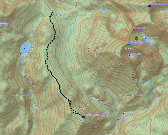
GPS Track


Date: 7/31/2013
Starting Elevation: 11,670ft
Geneva Mountain Summit: 12,335ft
Total Gained Elevation: 1,636ft
Class: 2
Distance: 8.05 miles
Time: 3:25 moving, 00:35 stopped. 
Climbing Partner: Solo


Tuesday, July 30, 2013

Threemile Creek

Kataka Mountain
I didn’t research this hike as much as I should have, and in doing so set myself up for failure.  I knew the weather was going to be crap, so I wanted to do something close to town.  I decided on Kataka Mountain and Spearhead Mountain.  Although we got a long hike in, Brian and I didn’t end up summiting either one of them.
Ptarmigan
Kataka and Spearhead can be accessed from Threemile Creek Trail in the Mount Evans Wilderness.  From Denver take 285 to Grant.  Grant is a very small town with a handful of structures, look for Al’s Pits BBQ on the north side of the road.  Take the one road, County 62 that heads north towards Guanella Pass.  A few miles down this road is the Threemile Creek TH.  Any operational vehicle can make it to the TH, but there is limited space and no restrooms.
We took off on the trail sometime around 7am.  The main section of the trail is about 2.5-3miles and follows along a creek.  This section is mostly covered in the trees and there are some 15 bridge crossings back and forth as you make your way up the trail.  After a good 2.5 miles the surroundings open up a bit and Kataka will be to the north and Spearhead to the south.  We decided to follow the length of the trail to the saddle in-between Kataka and Deer Creek. The upper section of the trail is much less used and heads up to the saddle of Kataka and Deer Creek, it runs an additional 3 miles.  I don’t suggest this for a climb of Kataka, since we hit 6miles around point 12075 which is probably a good mile from the summit of Kataka.  I’m sure there are more efficient ways to the summit, and I will let you know when I actually get there.
Mount Bierstadt
As I alluded to before we called it quits prior to summiting Kataka.  We settled on point 12075, which was about 6 miles and about 3,000ft into the hike.  This wasn’t a bad spot, since the views were quite impressive.  This spot gives you a unique view of Mount Bierstadt.  From here Bierstadt looks like a tough mountain to climb, not like the view from Guanella Pass.  We didn’t have too long to take in the views since we could see rain heading our way.  We decided for the direct descent down the north fork of Threemile Creek.  This way went pretty well, there was some navigating in the willows but nothing too difficult.  Brian even found a camera towards the lower section, so if you have lost one let me know.
Once back on the main trail the rain started in pretty good and kept up for most of the day.  My foot was killing me, so it was a slow painful process on the hike down.  Today I got diagnosed with Plantar Fascitis, so at least nothing is broken.  I guess I can keep hiking, which is a good thing.   After re-examining Google Earth and some other maps I think the next time I head for Kataka I will take the southwest ridge that starts where Threemile Creek starts heading to the east.  Either way we got a long hike in and a lot of time on the trail.  I’m hoping to head out to Geneva Mountain tomorrow, so with any luck you will have a real trip report to look at pretty soon.
GPS Track
Date: 7/29/2013
Starting Elevation: 8,985ft
Point 12075: 12,075ft
Total Gained Elevation: 3,190ft
Class: 1 (ascent) 2 (descent)
Distance: 11.2 miles
Time: 6:14 moving, 1:20 stopped. 
Climbing Partner: Brian

Thursday, July 25, 2013

Mount Flora

Mount Flora Summit
After a two day break it was time for another summit.  Unfortunately the weather has really turned to crap.  The forecast was for 60% chance of rain/thunderstorms after noon with winds in the 20’s and gusts of 30mph.  Well, those conditions are perfect…yeah right.  I met Brian at the TRex lot at 6am, and it was already raining …things are looking up..
Mount Flora starts from Berthound Pass on the Continental Divide Trail (CDT).  From Denver drive I-70 West to HWY 40, taking exit 233.  Follow HWY 40 up the windy switchback road till you arrive at Berthound Pass where there is a large parking lot.  We arrived in the cool frigid air, but the good news is that it was not raining.  Brian and I were previously up here in the late winter to climb CO Mines Peak, which starts from this same TH.  We were planning a Mount Flora and Breckinridge Peak hike when we left the TH around 7am.
Clouds Early in the Morning
I left the car with a light fleece on and shorts.  If I had better thought my clothing I would have worn pants, but I didn’t feel like changing.  Fog was covering the parking area and we knew we were going to get wet, it was just a matter of time.
The CDT starts at the main gate heading up a utility road.  As you can see in the GPS Track, follow the road for the first couple switchbacks then there will be a sign where the CDT splits off the main utility road.  From the parking lot it is a little under a mile to the trail sign of Mount Flora and Breckinridge Peak.  After the sign it is all trail to the summit, so a very nice class 1 hike.  Maybe half mile up the trailed section I started feeling a lot of moisture in the air, so we pulled out our rain gear for the remainder of the hike.  As we got closer to the saddle in-between CO Mines and Flora the wind picked up as did the rain.
The Mountains on the Way Down
The weather was coming in pretty hard and I really wished I had gloves at this point.  Lucky the sleeves on my jacket are long so I was able to cover up my hands with those.  It was a slow couple miles and at one point Brian had about had it with the weather, but we decided to move on up the mountain.  I figured since there was no thunder and lightning a little rain and wind wasn’t going to turn me back.  After all, what else was I going to do today?  Without too much suffering we finally made it up to the wide open summit.  There are some very large cairns leading to the true summit.  I noticed they kind of got bigger the closer that we got.  Once I confirmed with my GPS we were on the summit of Mount Flora we found a wind shelter to hunker down into.
I tried to snap a few pictures of the conditions, but I didn’t want to damage my camera so I only got a couple while in the midst of the storm.  After a few snacks we decided to bail on Breckinridge Peak and head back to the parking lot.  My fingers were starting to numb up so I put my trekking poles away and had to pocket my hands since I didn’t have gloves.  I guess this boy scout was not prepared today.  After about 10-15minutes feeling was back and I was good to go.  It was a nice hike down along the trail.  We ran into three people and one dog heading up.  I was surprised to see anyone else would be hiking in this weather, but I guess I shouldn’t be shocked since we were there.
Me and Brian on the Summit
Once dropping down from the main saddle the weather subsided and we were only in foggy conditions.  We took our time down and just followed the main road we used on the ascent.  The hike down progressively got warmer and we found ourselves at the car around 10:30am.  Brian didn’t disappoint with the beers.  He brought some Chicago native Old Style and there we sat in the parking lot drinking our beers as all the tourists sat there and taking photos of us.  The beer was pretty tasty, maybe next time Brian will bring up a deep dish pizza too!  Looks like James Peak on Monday assuming weather is decent.  Get out and climb some mountains.
GPS Track
Date: 7/25/2013
Starting Elevation: 11,307ft
Mount Flora summit: 13,146ft
Total Gained Elevation: 1,875ft
Class: 1
Distance: 6.33 miles
Time: 2:52 moving, 0:35 stopped. 
Climbing Partner: Brian

Tuesday, July 23, 2013

Mount Silverheels

Mount Silverheels
Now that summer is in full swing for me that means multiple climbs per week.  Just a few days ago a few of us climbed a nice 11er, but for this trip I choose a mountain a bit further from home that I have been eyeing for the past two years.  Mount Silverheels is in the Front Range, but as you look across highway 9 the Tenmile and Mosquito Ranges sit extremely close.  The first time I noticed Silverheels was on my ascent of Quandary Peak last year, which is a nearby 14er.  Silverheels looks like a massive daunting summit, and I believe it is commonly climbed and skied in the winter months.  I have eyed the South Ridge Route since I got Roach’s 13ers book, and we were not disappointed.
Brian was up for another hike, so we made plans to meet at our usual 285 parking spot of Meyer Ranch.  Getting to the Silverheels TH is quite simple.  From Denver follow 285 South till you are just outside of Fairplay, turn north onto 6th Street.  The sign for Fairplay will be just beyond this road so if you drive past the sign you will be taking a longer route to the TH.  Once on 6th Street follow it to Bogue Street and take a right (north), this turns into Beaver Lane which in time turns into Beaver Creek Road.  Follow this road till you see a sign on the right side of the road directing you to the Beaver Creek NF Access.  Where this sign is, is the winter TH…no thanks!  This is FS659 now; a few miles up the road you will pass the non-existent camp of Beaver Creek.  Your almost there, there was no sign for the FS184 road, but there was a sign for FS183 so just go up to the next road heading to the East.  The TH elevation should be 10,740ft so double check that and there will be a pretty good creek crossing. We parked here in an old makeshift campsite next to the creek.  A high clearance 4X4 would have no issue crossing the creek and driving the first mile of road.  Looking back it would have been nice to bring my truck, but we survived the extra 2 miles of hiking without issue.  After crossing the creek there will be an immediate Y junction, take the road heading up the hill to the NE.  Follow this road for about 1 mile till there is a clearly visible closed road on the left or north side of FS184.  This is considered the 4X4 parking and will cut the distance of the entire trip by about 2 miles if you have a worthy vehicle.
Big Bull Elk
As I was saying previously, we did not have the luxury of a 4X4 vehicle so we made the hike from the main road.  It went by pretty quick, but I did get devoured my plenty of mosquitos early on.  We actually had quite a late start since the weather forecast was good, so we didn’t step on the trail till about 8am.  The first mile only gains about 400 vertical feet so it’s pretty mellow, a mountain bike would be perfect.  If biking was your thing, you could easily bike nearly 3 miles each way along this route.
The Herd on the Ridge
After taking the closed road elevation starts gaining rapidly.  The nice thing if you like geology is that this section goes right through what appears to be the Morrison Formation.  There are a lot of good rocks specimens to look at in order to keep you mind occupied on the steep of the road.  It doesn’t last too long and eventually connects up with a much better road.  After looking at Google Earth, it appears the road you connect to is the same FS184, but that is a guestimation based on satellite imagery, nothing concrete.  From here the road is really mellow till you hit the base of PT 12,282.  From there the road is gone and there are some trail and some off trail hiking to be had.  I considered this a class 2 climb since we were off trail more than on, but it is a very easy route just sticking to the south ridge.
Quandary and the Tenmile Range
There are some ups and downs along the ridge so be prepared for that.  After we crossed PT 12,282 and dropped down the wind picked up probably to the low 30mph range and we had to throw on a jacket to protect from the chilling winds.  The unfortunate thing about this mountain is Silverheels looks so close all day.  You have to break this mountain up into layers and accomplish one at a time.  It is 4.5miles one way to the summit, so that is a pretty good distance to cover.  The route never got very steep, which eased the pain on my knees on the way down.  One of the better things about this hike is if you look to the west there is a hell of a view of some 14ers.
When the roller coaster finally ended and we were on the South Ridge proper, it was just a low angled hike to the top.  As we looked to the basin to the west we could see a massive herd of Elk.  I have never seen so many Elk in my entire life.  There had to be at least 100 of them down there.  As we moved up the ridge we could really hear them talking to one another.  This was a first time experience for me listening to their calls and I was pretty neat.  We were never really getting close to them, but eventually they started moving towards the west ridge.  I was able to find the Bull before they all made their way too far off, and he looked impressive.  The Elk were around 13,000ft high, I’m assuming they are this high to avoid the incredible heat down low but I’m no animal expert.
Quandary and Pacific
I was huffing pretty hard the last 1,000ft so the viewing of the Elk helped take my mind off of the torture.  Brian took off on me as I slowed, but we were still managing my pace of 1,000ft per hour so I was still happy with that.  The last 400ft or so turns into rock fingers and smaller amounts of grass.  I made my way up there and you could find trail-like areas here and there.  Somewhere around 11:30 am we were on the summit.
There were 4 others on top with us and one chocolate lab.  The sky was blue so the views all around were amazing.  With the zoom on my camera I could pick out about 8 people on Quandary.  It was nice relaxing on this summit, not having to worry about weather.  After a good 30minutes we started the descent.  I never look forward to the descent since my toes seem to burn in these Keen boots I have.  It wasn’t too bad, but the increase in temperature wasn’t making it too comfortable.  The hike down the ridge has an amazing view and that definitely helped the miles roll along.  It didn’t seem like too long and we were back to climbing up PT 12,282.  From there it’s a hike down a road.  We made it back to the car around 2pm or so and had a good beer.  I would recommend this route and I could see this mountain being a skiing paradise come winter.  I just may have to do that one day.


Date: 7/22/2013
Starting Elevation: 10,760ft
Mount Silverheels summit: 13,825ft
Total Gained Elevation: 3,415ft
Class: 2 (easy)
Distance: 9.00 miles
Time: 5:15 moving, 1:15 stopped. 
Climbing Partner: Brian

Friday, July 19, 2013

Rosedale Peak

Rosedale Peak
School Is Out For Summer!  You know, just imagine Alice Cooper is singing it.  I got lucky and was able to finish all my class work a week early, so last night after I got done I thought what would be a better reward than a summit?  I texted Brian and Paul and they were both in for a climb up Rosedale Peak.  Like usual the weather outlook was crap, so we decided a 6:30-7am start would be enough to get us up the mountain and off of it by noon to avoid any thunderstorms and rain. 
The trail starts from the Meridian TH #604.  Head south on 285, take a right at Park County 43 take this road to the “Y” then head right.  Pass Meridian CG then take the next left on Prospector Way, follow this to the end and that is the Meridian TH.  It’s easy to find and Brian’s Subaru did fine getting us there.  A few months back Brian and I made an attempt at this mountain but we were driven off by crap loads of snow and no snow shoes…that usually tends to be a problem.  So, once again we had some unfinished business to tend to.  This is a pretty simple route that involves minimal navigation skills.  Just follow the trail for the first 3 miles and some change then head directly up the East Ridge.  That’s how we did it, as you can see from the GPS track we caught onto a trail for the decent, but you could use that for the ascent if you didn’t want to have any fun with a good scramble.  I leave the choice to you.
Rosedale from the Base
Me Scrambling the Boulders Photo by Brian
As I said the hike is pretty straight forward.  The trail is kept in great shape, hopefully you are as well.  The first 1.25miles is pretty straight on a sandy rock trail.  After making the first real turn to your right the scenery will change and there will be a mixture of pine trees and aspen groves that you will walk through.  Just trudge along till you hit the saddle at about 3 miles; I think my GPS was reading 3.08miles where we stopped for a break at the saddle.  From the saddle we took the East Ridge direct route, there is no trail from here on so just stick to the ridge.  There trees and brush aren’t too thick so you can meander your way up the ridge pretty easily.  After a few hundred feet the boulder fields will start appearing, do as we did and climb them directly.  It was a lot of fun, and all easy class 3 climbing.  The rock is very stable, so a nice place for beginners to learn scrambling.  Just follow the boulders up, up, up till you reach the top of the false summit.  Sorry, did I mention there was going to be false hope on this climb?  Well, there usually is so that’s life.  After the false summit you can see the true summit, just make your way down to the small saddle in-between them and head up to the true summit.  Once on top the true summit ridge it becomes a bit hard to tell the true summit.  There are a bunch of rock groups progressing along the ridge; I ended up using my GPS to nail down the correct rock pile.
After we all had a quick summit lunch we decided to be on our way to avoid the oncoming clouds of death headed our way.  Unfortunately I didn’t take many photos on this climb.  When I get on scrambles I like to keep the camera in my bag so I don’t ruin it, so I guess you will have to deal with the lack of pictures on this one.  Anyway, as I was saying, the clouds were getting big and fluffy so we decided to descend the trail rather than re-trace the East Ridge route we ascended.  This was rather painless, we just had to drop maybe 500ft and we eventually ran across the trail.
From the trail it was just a hike out, maybe 4-5 miles from where we met it to the car.  We all seemed to be moving well today so we continued on our hike till we were back to the saddle, meaning we still had a dreadful 3 miles to the car.  Well, I guess that would be a lie as well, it wasn’t that dreadful, if you want dreadful hike the boulders of Mount Massive now that is dreadful.  The trail was actually pleasant.  There was good tree cover from the sun, the breeze was pretty constant, so I guess I can’t really complain.  During our short break we realized we were surrounded by cloud and all of us were thankful to be off the mountain and in the trees.  I ate a Pay Day candy bar and it was sure good.  Then we were off.
The last three miles flew by pretty quickly, we didn’t really stop but just for a few rock clearing of the shoe types.  We never got rained on; maybe felt a few sprinkles but that could have been the mass quantities of sweat falling from my face as well.  It was a great hike right around 9 miles with a great scrambling section to boot.  I would definitely come back to this one, and one of the best parts is we didn’t see anyone all day…and that is rare in Colorado!
GPS Track
Date: 7/19/2013
Starting Elevation: 9,040ft
Rosedale Peak summit: 11,825ft
Total Gained Elevation: 3,035ft
Class: 3
Distance: 9.05 miles
Time: 4:33 moving, 1:10 stopped. 
Climbing Partner: Brian and Paul


Saturday, July 13, 2013

Grays and Torreys


My buddy Craig is in his last bit of training for a climb of Mt. Rainier in a couple weeks and he contacted me to see if I could get out on Friday.  I was happy to join him; I always love talking about the Cascade Volcanoes.  We had a difficult time deciding on what mountain to climb since the weather everywhere was forecasting so poor.  With a 50% chance of thunderstorms by 9am all along the Front Range we decided to go with Grays and Torreys with a 5:30am start time.  I have previously done Grays and Torreys but individually, so I was looking forward to doing them together this time.  For Craig he had not done Torreys yet, so he would at least get a new 14er under his belt.
On Thursday we sent out a message to see if anyone wanted to join us and got no response so it was just Craig and me on this one.  We met at 4:30am at the T-Rex lot on I-70.  As we pulled off of the Bakerville exit and got onto the dirt road to the Stevens Gulch TH we both noticed how the road was in really poor shape.  Last year I went up to this TH four times and have never seen the road so bad, but there were still cars at the top.  Some people just don’t care about their vehicles I guess.  On the disturbing side of things, we could smell the pit toilet across the lot so avoid this at all costs and find a tree.  The main lot was almost full, with only about five spaces left at 5:30, so we knew the trail would be busy today.  We were finally off around 5:45am, along with about 15 others.  One of us still had some business to tend to so it was a slow hike over the first 1.5miles, which is where the first main sign along the trail is.  It was a bit chilly and the wind was gusty so I couldn’t decide whether to keep my jacket on or off.  As long as we were moving the jacket off option worked best, and I was glad I went with pants over shorts today because it stayed on the cool side the entire day.
Torreys from Grays Peak
After making the corner heading to the west past the sign I was talking about the mountains really open up and you get amazing views of Grays and Torreys.  This is probably one of the most photographed spots in the area, I know I have a 20 or so photos of the Dead Dog Couloir.  From this point there is about 2,000ft elevation gain over about 2miles.  This is where you can get mentally beat, especially when you have hiked this trail so many times.  Just find your happy place, get some good views of Torreys in and trudge along up the trail.  For the first timers it will be a lot easier, but I find it much more difficult to do these hikes, while enduring some pain when you have been there before.
Edwards
After the end of the long, long switchbacks I made the summit of Grays about 8:45am.  There was only one group of three guys up there when I arrived, so I tagged the top and found a wind shelter to enjoy my snickers bar.  The weather looked good so far, so I’m not sure where the forecast of thunderstorms at 9am came from.  I watched as Craig came up the last few switchbacks and we were finally both on summit number 1 for day.  After some fuel and a few pictures, Craig said he was good to try for Torreys so off we went.  I didn’t think it would take too long, but we closely watched the weather so we wouldn’t get surprised by any developing storms.
The last half-mile up Torreys was steep and seemed eternal.  We took our time and eventually made it to Torreys summit.  Summit number 2 of the day was had and it was a small crowded one.  There was a good 20 people at least on top.  There was even an older guy doing push-ups….weirdo.  We could see storms building so we knew it was time to go.  We slowly made our way down to the saddle and found the trail that cuts across the face of Grays back down to the main trail.  There was a snow crossing that was more like a ledge.  I wouldn’t recommend doing this crossing early in the morning, since it was a little dicey around noon.
We could see the black clouds starting to make their way over Grays and we were about off the steep sections so we thought we were good.  After some trudging down the rocky trail we were finally down into the basin again.  The thunder and lightning was starting to surround the mountains and then came the rain.  Craig suggested rain coats, so we stopped and dug them out of our bags.  About two seconds later the down pour commenced.  We had a good rain to deal with for the remainder of a mile and a half or so.  As the storm passed I was sweating pretty good with my coat on so I made the idiotic move of putting my jacket back in my bag.  It was great for about 10 minutes, then it all started again.  My ankles were done, but I tried to double-time it down the trail to the car.  That didn’t work to well either, but we eventually made it back to the car.  The rain was still in a downpour so we saddled up quickly into the car and were off.
Another hiker asked for a ride down to his car so he joined us down the bumpy, muddy road.  We had a serious hunger for Tommyknockers so; a quick stop in Idaho Springs was the key to finishing our climb.  It was a great day hiking with Craig, and always good to get out in the mountains.  I wish I was joining him on Rainier, so good luck Craig and have a great birthday climb!
GPS Track
Date: 7/12/2013
Starting Elevation: 11,280ft
Grays Peak summit: 14,270ft
Torreys Peak summit: 14,267ft
Total Gained Elevation: 3,600ft
Class: 2
Distance: 8.45 miles
Time: 5:45 moving, 2:00 stopped. 
Climbing Partner: Craig

Tuesday, July 9, 2013

Titus Ridge Idaho


Titus Peak

It is already the 4th of July holiday, so time for another adventure to Idaho.  We planned a short trip to the Hailey area for about 3 days, so I had time to meet up with a few friends and get a short hike in.  Mike, Steve and Michelle were all up for a hike on Titus Ridge so we set a date for Saturday July 6th.  After the long drive from Denver (about 11hrs) I took a night to rest.  Somewhere during that time I got a nasty sunburn on my shoulders, so I can’t say I was looking forward to putting a pack on. 
On Friday evening Mike, Steve and I met up at the Prairie Creek CG and lucky for us In the Wild Chef was happy to cook.  We decided on Salmon and rice for dinner, which I must say was the best I have eaten camping before.  Steve doesn’t mess around; he makes it look way to easy.  The three of us had a few beers and hung out till around 11pm then hit the hay.  Waking around 6am the next morning the Chef was already busy at it making us coffee and Blueberry Beercakes!  Steve is a blessing from the gods; it was a great way to wake up on a chilly morning.  I must say one of the most impressive sights was watching Mike pack away the Beercakes, some 7 or so I think.  And these were not silver dollar cakes either, they filled a plate…that a boy Mike!
Michelle arrived around 7am, so we packed up the rest of camp and made our way up to Galena Pass.  There was a tiny spot to park on the west side of the pass right where the trail started, so off we went.  The first section of trail didn’t mess around with gaining elevation, so we all got a nice kick start early in the morning.  It was nice since it was still cool; a few in the group were still wearing long sleeves and pants, that didn’t last too long.  There was a lot of fallen trees over the first mile of trail, so be ready for some hurdles if you head up this way.  We took a very “social” pace for the entire day so it seemed pretty relaxed and was very enjoyable to me.  After gaining the first hump around the 9,600ft contour the trail dissipates for a bit, but you can pick it up on the downside (west side) before heading up to the next point on the roller coaster.  As big as these bumps on the trail seemed to be, it felt like we were going up them pretty quickly.
Once we made it up Lower Titus (not sure if that is the correct name) at 10,005ft we took a short break for some fluids and fuel.  There is a small weather monitoring station on top of this point and some of the most amazing views you can imagine.  A few in the group seemed a little concerned about the route up Titus, weather there would be a trail or a route through the rocks.  We were lucky and found that there was a trail almost all the way to the summit.  Not a trail by Colorado standards, but it worked for all of us.  After a little side hilling across some kitty litter we made it around the big rocks and joined the summit ridge about 100yrds east of the true summit.  From there it was a walk to the top of Titus.
The weather was still pretty good, the breeze was keeping us cool and the clouds helped out now and then covering the scorching sun.  We took about 30 minutes on top having summit beers and Steve brought up some of his Spicy Hummus which was out of this world amazing.  I typically don’t go for hummus, but this was a bit of the good life.  We got our Duck pictures in and decided we should make our way off the kitty litter before the rain came in.  Before departing I stood in awe of Castle, a peak I have not climbed yet, but what a beauty it was!
Our descent off of Titus took us down a bit further trying to find a good game trail to cut across so there were portions that were less than enjoyable, but we found one eventually.  After I dumped the pebbles out of my trail runners we were off down the rest of the trail.  Nobody was looking forward to hiking back over the roller coaster humps we ascended on the way to Titus, but I thought it would beat the misery of a long side-hill adventure.  In no time at all we were up and over all of the humps and on the final descent back to Galena Pass.  It looked like the Pioneers were getting a good bit of rain, so I was counting my blessing we chose the Smokys today.  This is an amazing ridge for those that haven’t done it and I would highly recommend it.  Next time I would like to take it all the way to Saviers, looks like some good scrambling the further out you get.  I always enjoy hiking with my old friends in Idaho, now it’s time for you guys to get to Colorado and we will tag a few 14ers together!
For those of you looking to “spice” up your camping meals check out my friend book:  In The Wild Chef: Recipes From Base Camp To Summit by Steve Weston.  On this trip he made us Big Dan’s Spicy Hummus on page 15, Trail Pancakes – Blueberry Beercakes with fresh blueberries and blueberry syrup page 131, Wild Jalapeno Mushroom Salmon with Rice page 177.  The book can be purchased online at: http://www.amazon.com/In-The-Wild-Chef-Recipes/dp/1927458064/ref=sr_1_1?ie=UTF8&qid=1373386179&sr=8-1&keywords=in+the+wild+chef
GPS Track


Date: 7/6/2013
Starting Elevation: 8,700ft
Lower Titus Summit: 10,005ft
Titus Summit: 10,110ft
Total Gained Elevation: 2,343ft
Distance: 6.14 miles
Time: 4hrs moving, 1:45 stopped. 
Climbing Partner: Mike, Steve, Michelle